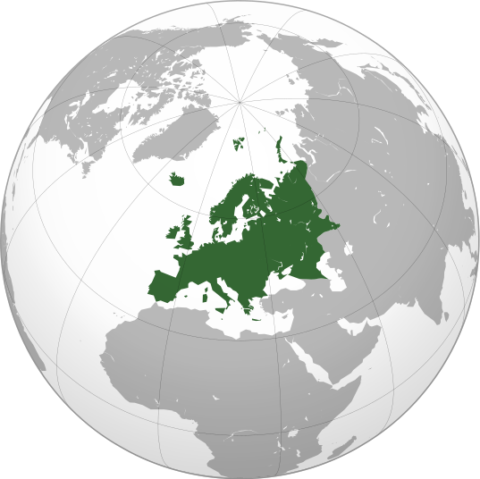
Plik:Europe orthographic Caucasus Urals boundary.svg

Wielkość pliku podglądu PNG dla pliku SVG: 537 x 536 pikselōw Inksze rozdzielczości: 240 x 240 pikselōw | 481 x 480 pikselōw | 769 x 768 pikselōw | 1026 x 1024 pikselōw | 2052 x 2048 pikselōw.
Ôryginalny zbiōr (Zbiōr SVG, nōminalnie 537 × 536 pikselōw, srogość zbioru: 77 KB)
Gyszichta zbioru
Kliknij w datã/czas, żeby ôbejzdrzeć zbiōr, jak wtynczŏs wyglōndoł.
| Data i czas | Miniatura | Wymiary | Używŏcz | Kōmyntŏrz | |
|---|---|---|---|---|---|
| terŏźnŏ | 15:32, 4 wrz 2022 |  | 537 × 536 (77 KB) | M.Bitton | Reverted to version as of 12:03, 4 September 2022 (UTC): per COM:OVERWRITE |
| 15:30, 4 wrz 2022 |  | 537 × 536 (177 KB) | Рагин1987 | Small correction | |
| 14:03, 4 wrz 2022 |  | 537 × 536 (77 KB) | M.Bitton | Reverted to version as of 05:48, 12 March 2019 (UTC): per COM:OVERWRITE + fake svg | |
| 21:12, 30 siy 2022 |  | 2052 × 2048 (874 KB) | Рагин1987 | More correct visualization of the dividing line on the territory of the Caucasus Range | |
| 07:48, 12 mar 2019 |  | 537 × 536 (77 KB) | AndreyKva | Optimized. | |
| 21:25, 3 mar 2016 |  | 537 × 536 (197 KB) | Denniss | Reverted to version as of 13:27, 19 October 2014 (UTC) | |
| 20:37, 3 mar 2016 |  | 537 × 536 (239 KB) | Ercwlff | UC UC UC | |
| 15:27, 19 paź 2014 |  | 537 × 536 (197 KB) | Deni Mataev | Again, The entirety of Georgia is not in Europe geographically, only North Eastern parts are | |
| 22:05, 18 paź 2014 |  | 537 × 536 (238 KB) | Politologia | Reverted to version as of 10:57, 18 October 2014 In all maps Georgia is part of Georgia. There is at list 10 versions of borders of Europe in most of them Georgia is part of Europa | |
| 22:04, 18 paź 2014 |  | 537 × 536 (238 KB) | Politologia | Reverted to version as of 10:57, 18 October 2014 In all maps Georgia is part of Georgia. |
Użycie zbioru
Te strōny używajōm tego zbioru:
Globalne użycie zbioru
Tyn zbiōr je używany tyż we inkszych projektach wiki:
- Użycie we ab.wikipedia.org
- Użycie we ace.wikipedia.org
- Użycie we ady.wikipedia.org
- Użycie we af.wikipedia.org
- Użycie we ar.wikipedia.org
- بوابة:آسيا
- بوابة:أوروبا
- بوابة:إفريقيا
- بوابة:القارة القطبية الجنوبية
- بوابة:القارة القطبية الجنوبية/بوابات شقيقة
- قائمة جوازات السفر
- بوابة:تركيا
- بوابة:تركيا/بوابات شقيقة
- بوابة:جغرافيا/مقالة مختارة/أرشيف
- المرأة في تركيا
- بوابة:أوروبا/واجهة
- بوابة:تصفح
- بوابة:تصفح/جغرافيا
- قائمة مفاتيح الاتصال الدولية
- المرأة في ألمانيا
- بوابة:إسطنبول
- بوابة:آسيا/بوابات شقيقة
- ويكيبيديا:مقالة الصفحة الرئيسية المختارة/398
- بوابة:جغرافيا/مقالة مختارة/21
- معاملة المثليين في أوروبا
- المرأة في أوروبا
- المرأة في البرتغال
- المرأة في فنلندا
- المرأة في مقدونيا الشمالية
- المرأة في ترانسنيستريا
- المرأة في الفاتيكان
- المرأة في أذربيجان
- المرأة في اليونان
- المرأة في ألبانيا
- المرأة في إيطاليا
- المرأة في الجبل الأسود
Pokŏż listã globalnego użyciŏ tego zbioru.

