Plik:Kingdom of Prussia 1870.svg

Wielkość pliku podglądu PNG dla pliku SVG: 450 x 456 pikselōw Inksze rozdzielczości: 237 x 240 pikselōw | 474 x 480 pikselōw | 758 x 768 pikselōw | 1011 x 1024 pikselōw | 2021 x 2048 pikselōw.
Ôryginalny zbiōr (Zbiōr SVG, nōminalnie 450 × 456 pikselōw, srogość zbioru: 705 KB)
Ôpis
Ta ^specifik^ z W3C grafika wektorowa została stworzona za pomocą Inkscape .


.svg)
.svg)
.svg)
.svg)
.svg)


.svg)
.svg)
.svg)


.png)
.png)


.svg)


.svg)

.svg)


.svg)
.svg)
.svg)
.svg)


.svg)
.png)


.svg)


.svg)
.svg)


.svg)


.svg)


.svg)
.svg)
.svg)
.svg)
.svg)
.svg)
.svg)
_cropped.svg)
.svg)
.svg)
.svg)
.svg)
.svg)
.svg)
.svg)
.svg)
.svg)
.svg)
.svg)
.svg)
.svg)
.svg)
.svg)
.svg)
.svg)
.svg)
.svg)
.svg)
.svg)
.svg)
.svg)
.svg)
.svg)
.svg)
.svg)
.svg)
.svg)
.svg)
.svg)
.svg)
.svg)
.svg)
.svg)
.svg)
.svg)
.svg)
.svg)
.svg)
.svg)
.svg)
.svg)
.svg)
.svg)
Licyncyjŏ
Ten plik udostępniony jest na licencji Creative Commons Uznanie autorstwa – Na tych samych warunkach 4.0 Międzynarodowe.
- Idzie:
- udostympniać – kopiować, rozkludzać i przekazować dzieło
- modyfikować – adaptować dzieło
- Pod tymi warōnkami:
- uznanie autorstwa – Musisz ôkryślić autorstwo, podać link do licyncyje, i skŏzać, czy dzieło było zmiyniōne. Możesz to zrobić kożdym usōndnym spusobym, ale niy tak, żeby sugerować, że posiedziciel licyncyje spiyrŏ Ciebie abo Twoje użycie dzieła.
- trzim licyncyjõ – Jeźli zmiyniŏsz abo budujesz na tyj materyji, musisz swoje dzieło rozkludzać na takij samyj abo zgodliwyj licyncyji, jak we ôryginale.
Gyszichta zbioru
Kliknij w datã/czas, żeby ôbejzdrzeć zbiōr, jak wtynczŏs wyglōndoł.
| Data i czas | Miniatura | Wymiary | Używŏcz | Kōmyntŏrz | |
|---|---|---|---|---|---|
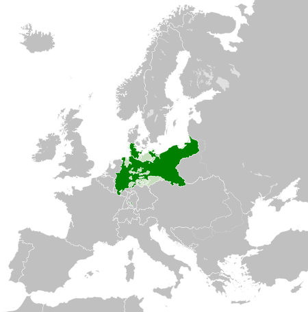
| terŏźnŏ | 04:54, 1 czy 2016 | | 450 × 456 (705 KB) | Alphathon | Various corrections to the states of the North German Confederation |
| 07:22, 31 mŏj 2016 |  | 450 × 456 (662 KB) | Alphathon | Minor corrections (Tarasp and post-1818 German Confederation border change) | |
| 04:40, 31 mŏj 2016 |  | 450 × 456 (662 KB) | Alphathon | == {{int:filedesc}} == {{Inkscape}} {{Information |Description={{en|A map of the en:Kingdom of Prussia within the North German Confederation and within Europe circa 1870 CE.}} |Source= {{Derived from|Blank_map_of_Europe.svg|display=50}} |Da... |
Użycie zbioru
Ta strōna używŏ tego zbioru:
Globalne użycie zbioru
Tyn zbiōr je używany tyż we inkszych projektach wiki:
- Użycie we af.wiktionary.org
- Użycie we ar.wikipedia.org
- Użycie we bn.wikipedia.org
- Użycie we ckb.wikipedia.org
- Użycie we en.wikipedia.org
- Użycie we eo.wiktionary.org
- Użycie we es.wikipedia.org
- Użycie we es.wiktionary.org
- Użycie we eu.wikipedia.org
- Użycie we fa.wikipedia.org
- Użycie we fi.wikipedia.org
- Użycie we he.wikipedia.org
- Użycie we hu.wikipedia.org
- Użycie we is.wikipedia.org
- Użycie we it.wikipedia.org
- Użycie we li.wiktionary.org
- Użycie we lld.wikipedia.org
- Użycie we lt.wikipedia.org
- Użycie we mn.wikipedia.org
- Użycie we pl.wikipedia.org
- Użycie we rue.wikipedia.org
- Użycie we ru.wikipedia.org
- Użycie we ru.wiktionary.org
- Użycie we sk.wikipedia.org
- Użycie we tr.wikipedia.org
- Użycie we uk.wikipedia.org
- Użycie we uz.wikipedia.org
- Użycie we xmf.wikipedia.org
- Użycie we zh.wikipedia.org