Plik:Queens Road - geograph.org.uk - 212549.jpg
Niy ma dostympnyj srogszyj rodzielczości.
Queens_Road_-_geograph.org.uk_-_212549.jpg (640 × 479 pikselōw, srogość zbioru: 153 KB, zorta MIME: image/jpeg)
Ôpis
| Ôpis |
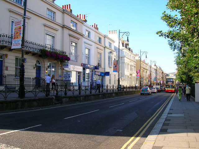
English: Queens Road. Taken from the junction of Church Street and Queens Road. Queens Road was constructed in 1845 to connect Brighton town centre with the newly opened Brighton station. Parts of the route were already occupied, to the south of this junction was Air Street a small slum area part of which still links Queens Road to Queens Square, whilst to the north was Windsor Terrace constructed in the 1830s. Unlike the slums Windsor Terrace still survives today as does the original walkway originally built next to a graveyard part of which survives to the right of the road today and is now a small park. The new road was built at a higher elevation than the old graveyard but lower than Windsor Terrace. The white building in the middle of the terrace is a Freemasons Lodge constructed in the 1920s.
Click on the link to take you to the next page. https://www.geograph.org.uk/photo/212550 |
| Data | |
| Zdrzōdło | From geograph.org.uk |
| Autōr | Simon Carey |
| Uznanie autorstwa (wymagana przez licencję) | Simon Carey / Queens Road / |
| Pozycja fotografa | | To i inne zdjęcia na: OpenStreetMap |
|---|
_heading:45.00&language=szl)
| Pozycja obiektu | | To i inne zdjęcia na: OpenStreetMap |
|---|
_heading:45.00&language=szl)
Licyncyjŏ

|
Ta grafika pochodzi z kolekcji projektu Geograph. Aby zobaczyć szczegóły możesz odwiedzić stronę tego zdjęcia w serwisie Geograph. Prawa autorskie do tej grafiki posiada Simon Carey i jest ona udostępniona na licencji Creative Commons Uznanie autorstwa – Na tych samych warunkach 2.0.
|
Ten plik udostępniony jest na licencji Creative Commons Uznanie autorstwa – Na tych samych warunkach 2.0.
Uznanie autorstwa: Simon Carey
- Idzie:
- udostympniać – kopiować, rozkludzać i przekazować dzieło
- modyfikować – adaptować dzieło
- Pod tymi warōnkami:
- uznanie autorstwa – Musisz ôkryślić autorstwo, podać link do licyncyje, i skŏzać, czy dzieło było zmiyniōne. Możesz to zrobić kożdym usōndnym spusobym, ale niy tak, żeby sugerować, że posiedziciel licyncyje spiyrŏ Ciebie abo Twoje użycie dzieła.
- trzim licyncyjõ – Jeźli zmiyniŏsz abo budujesz na tyj materyji, musisz swoje dzieło rozkludzać na takij samyj abo zgodliwyj licyncyji, jak we ôryginale.
Gyszichta zbioru
Kliknij w datã/czas, żeby ôbejzdrzeć zbiōr, jak wtynczŏs wyglōndoł.
| Data i czas | Miniatura | Wymiary | Używŏcz | Kōmyntŏrz | |
|---|---|---|---|---|---|
| terŏźnŏ | 02:02, 1 lut 2010 | | 640 × 479 (153 KB) | GeographBot | == {{int:filedesc}} == {{Information |description={{en|1=Queens Road. Taken from the junction of Church Street and Queens Road. Queens Road was constructed in 1845 to connect Brighton town centre with the newly opened Brighton station. Parts of the route |
Użycie zbioru
Ta strōna używŏ tego zbioru:
Globalne użycie zbioru
Tyn zbiōr je używany tyż we inkszych projektach wiki:
- Użycie we azb.wikipedia.org
- Użycie we en.wikipedia.org
- Użycie we sl.wikipedia.org