Plik:Republic of Venice 1789.svg

Wielkość pliku podglądu PNG dla pliku SVG: 450 x 456 pikselōw Inksze rozdzielczości: 237 x 240 pikselōw | 474 x 480 pikselōw | 758 x 768 pikselōw | 1011 x 1024 pikselōw | 2021 x 2048 pikselōw.
Ôryginalny zbiōr (Zbiōr SVG, nōminalnie 450 × 456 pikselōw, srogość zbioru: 927 KB)
Ôpis


.svg)
.svg)
.svg)
.svg)
.svg)


.svg)
.svg)
.svg)


.png)
.png)


.svg)


.svg)

.svg)


.svg)
.svg)
.svg)
.svg)


.svg)
.png)


.svg)


.svg)
.svg)


.svg)


.svg)


.svg)
.svg)
.svg)
.svg)
.svg)
.svg)
.svg)
_cropped.svg)
.svg)
.svg)
.svg)
.svg)
.svg)
.svg)
.svg)
.svg)
.svg)
.svg)
.svg)
.svg)
.svg)
.svg)
.svg)
.svg)
.svg)
.svg)
.svg)
.svg)
.svg)
.svg)
.svg)
.svg)
.svg)
.svg)
.svg)
.svg)
.svg)
.svg)
.svg)
.svg)
.svg)
.svg)
.svg)
.svg)
.svg)
.svg)
.svg)
.svg)
.svg)
.svg)
.svg)
.svg)
.svg)
Licyncyjŏ
Ja, właściciel praw autorskich do tego dzieła, udostępniam je na poniższej licencji
Tyn zbiōr podlygŏ licyncyji Creative Commons Uznanie autorstwa – Na tych samych warōnkach 3.0.
- Idzie:
- udostympniać – kopiować, rozkludzać i przekazować dzieło
- modyfikować – adaptować dzieło
- Pod tymi warōnkami:
- uznanie autorstwa – Musisz ôkryślić autorstwo, podać link do licyncyje, i skŏzać, czy dzieło było zmiyniōne. Możesz to zrobić kożdym usōndnym spusobym, ale niy tak, żeby sugerować, że posiedziciel licyncyje spiyrŏ Ciebie abo Twoje użycie dzieła.
- trzim licyncyjõ – Jeźli zmiyniŏsz abo budujesz na tyj materyji, musisz swoje dzieło rozkludzać na takij samyj abo zgodliwyj licyncyji, jak we ôryginale.
Oryginalny rejestr przesyłania
This image is a derivative work of the following images:
- File:Europe_1789.svg licensed with Cc-by-sa-3.0
- 2013-04-14T03:44:26Z Alphathon 450x456 (858577 Bytes) Corrected some errors in northern Italy
- 2013-04-14T01:38:01Z Alphathon 450x456 (853881 Bytes) tweaked again
- 2013-04-14T01:36:10Z Alphathon 450x456 (853881 Bytes) Tweaked Holy Roman Empire border style
- 2013-04-14T01:33:26Z Alphathon 450x456 (853857 Bytes) == {{int:filedesc}} == {{Information |Description={{en|A blank Map of Europe circa 1789. This map also includes a border for the [[:en:Holy Roman Empire|Holy Roman Empire]]. Since there are so many small German states, they h
Uploaded with derivativeFX
Gyszichta zbioru
Kliknij w datã/czas, żeby ôbejzdrzeć zbiōr, jak wtynczŏs wyglōndoł.
| Data i czas | Miniatura | Wymiary | Używŏcz | Kōmyntŏrz | |
|---|---|---|---|---|---|
| terŏźnŏ | 00:20, 27 lis 2021 | | 450 × 456 (927 KB) | Cplakidas | Fixing Venetian Albania, adding Cythera to Venice |
| 09:55, 17 paź 2021 |  | 450 × 456 (803 KB) | Fenn-O-maniC | Fixed the Russo-Swedish border to match the Treaty of Åbo of 1743 | |
| 11:23, 27 lut 2020 |  | 450 × 456 (821 KB) | Facquis | Clear map | |
| 19:16, 18 kwi 2013 |  | 450 × 456 (820 KB) | Alphathon | Various fixes | |
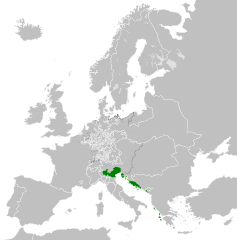
| 05:54, 14 kwi 2013 |  | 450 × 456 (802 KB) | Alphathon | == {{int:filedesc}} == {{Information |Description={{en|A map of the Republic of Venice circa 1789.}}{{de|Eine Landkarte die Republik Venedig c. 1989.}} |Source={{Derived from|Europe_1789.svg|display=5... |
Użycie zbioru
Ta strōna używŏ tego zbioru:
Globalne użycie zbioru
Tyn zbiōr je używany tyż we inkszych projektach wiki:
- Użycie we azb.wikipedia.org
- Użycie we bg.wikipedia.org
- Użycie we ca.wikipedia.org
- Użycie we ckb.wikipedia.org
- Użycie we cs.wikipedia.org
- Użycie we de.wikipedia.org
- Użycie we el.wikipedia.org
- Użycie we en.wikipedia.org
- Użycie we eu.wikipedia.org
- Użycie we fa.wikipedia.org
- Użycie we fy.wikipedia.org
- Użycie we he.wikipedia.org
- Użycie we hi.wikipedia.org
- Użycie we hr.wikipedia.org
- Użycie we it.wikipedia.org
- Użycie we ko.wikipedia.org
- Użycie we lfn.wikipedia.org
- Użycie we lij.wikipedia.org
- Użycie we lmo.wikipedia.org
- Użycie we mk.wikipedia.org
- Użycie we ml.wikipedia.org
- Użycie we ms.wikipedia.org
- Użycie we pl.wikipedia.org
- Użycie we pt.wikipedia.org
- Użycie we rue.wikipedia.org
- Użycie we ru.wikipedia.org
- Użycie we sk.wikipedia.org
- Użycie we tr.wikipedia.org
- Użycie we uk.wikipedia.org
- Użycie we zh.wikipedia.org